
Iziko_SAMLB_D_!n007
Metadata
Iziko_SAMLB_D_!n007
Watercolours
!nanni
image
pencil
15 September 1881
315x254
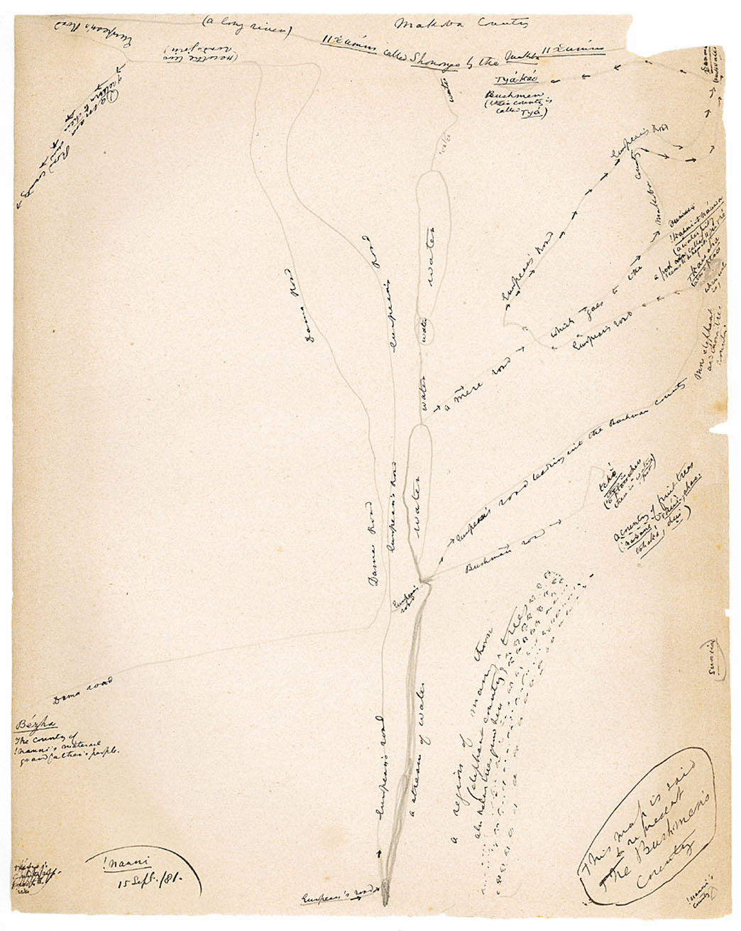
This map is said to represent the Bushmen's country, !nanni's country, a region of many thorn trees (elephant country) also Naba trees grow here, sunrise, a country of fruit trees (!naxane, |kui, shao, tshaka, dui), Bushman road, tcho (this is a place where there is a water pit), European's road leading into the Bushman country, more elephant and thorn-tree country, water, a mere road, which goes to the Makoba country, European's road, !kanni ≠nauwa (a water-pit), a pool called ||gu |ne seems to be near it, |kau sha (also a place where water is), European's road, xamma (much water), water, water, water, water, |ya-kao Bushmen (their country is called |ya), Makoba country, a long river, ||xumm called Shonongo by the Makoba, ||xumm, European's road, Dama road, Here the two roads join, European's road, Damara Road of return to their own country, European's road, European's road, a stream of water, Bezha, The country of !nanni's maternal grandfather's people, Dama road
personal history
relations with others
plants and animals
custom and daily life
map ( !nanni's maternal grandfather's people )
map ( !nanni's country )
map ( !kun country )
plant ( in map of !nanni's country )
plant ( fruit and thorn trees )
animal ( elephant )
animal ( in map of !nanni's country )
European ( road )
European ( and map of !nanni's country )
Bushmen ( |ya-kao )
Bushmen ( their country )
Bushmen ( and map of !nanni's country )
personal history ( map of his country )
water ( 'much' )
water ( -place )
water ( -pool )
water ( -pit )
water ( and map of !nanni's country )
road ( European's )
road ( Damara )
road ( and map of !nanni's country )
Makoba ( country )
Makoba ( and map of !nanni's country )
Damara ( road )
Damara ( and map of !nanni's country )
Ovaherero ( Dama road )
Ovaherero ( and map of !nanni's country )
Contributions